Innovations
Since its inception, Science and Technology Corporation (STC) has been committed to innovative R&D activities and other initiatives that provide value-add to our customers as well as opportunities for young researchers.
Some of our recent research projects include:
Digital Twin
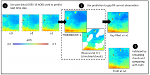
Every day, the National Environmental Satellite, Data, and Information Service (NESDIS) produces hundreds of Earth data products from low earth orbit, geostationary, and space weather satellites within NOAA. NESDIS employs complex computing strategies to govern the sensors-to-user pipeline for downlinking, ingesting, processing, and disseminating over 17 Pb of data in near real-time. However, there are opportunities to enhance data processing using cutting-edge technologies like machine learning and computer vision using digital twin technologies. Digital Twins can serve a dual role by optimizing the ground system’s performance and acting as a sandbox for testing enhancements without disrupting existing operations.
This presentation describes our rapid efforts to build an Earth-Observation Digital Twin (EO-DT) prototype to enhance data discovery, reduce dissemination challenges, and automate data quality control within NESDIS. We focus on critical features, such as rapid data cataloging, querying, and data anomaly detection using computer vision. Using an Air Quality case study, we also explore fusing data products from multiple sources, which can create analysis-ready datasets for seamless end-user access. Numerous successful digital twin projects are underway, and the community envisions this will lead to a federation of interconnected digital twins. We will share our software approach, enabling technologies, successes, and lessons learned with the community to work toward digital twin interoperability.
SonicSonde
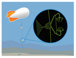
The SonicSonde is an advanced, tethered instrument suite used for in-situ atmospheric sampling. Capable of prompt, repetitive vertical ascent, the suite is used to measure key state variables of the atmosphere including pressure, temperature, relative humidity, air-quality and three-dimensional wind velocities. Ascent patterns target a vertical column extending from the surface to 5,000 ft above ground level. In addition, custom-developed computer software is used to support and display real-time data as it wirelessly streams from the SonicSonde during operation.
The objective of the SonicSonde is to combat hindrances in most state-of-the-art tethered systems via development of an advanced, versatile, and lightweight sensor suite. This comprehensive sensor suite provides three-dimensional wind data to a degree and resolution currently not obtainable in tethered instrumentation, allowing for progressive atmospheric research in the field.
By the end of development: the complete prototype frame was constructed; all sensors proposed were fully operational onboard the SonicSonde platform (sonic anemometer, temperature/relative humidity, pressure, and air-quality); data was routinely collected during ascent via the onboard sensors at rates up to 10Hz and piped wirelessly to the ground station where the custom software package displayed the data; and several ascent tests were conducted proving capability of the SonicSonde to measure and successfully relay real-time data through altitudes beyond 5,000 ft above ground level.
An official patent application for this technology was filed 12 Aug 2022. NDA for commercialization discussions have been signed with additional agreements welcomed.
For more information see also NASA Feature: NASA Armstrong takes Weather Instrumentation to New Heights – NASA
iPhotometer
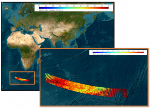
The iPhotometer (patented) is a sun-photometer that can be used to estimate aerosol optical depth and size distribution by analyzing sky scattered sunlight. Using a cell phone with GPS as the platform, the iPhotometer has the potential to be a low-cost alternative to current expensive instruments. The iphotometer – seen in the picture to the right – was developed by STC with NASA funding.
Included with the iPhotomoter is desktop/laptop software that processes captured images and ultimately estimates the aerosol optical depth and size distribution as shown in Figs. 1-4 below.
 iPhotometer
  Figure 1: Captured Image
  Figure 3: Variation in light intensity along the almucantar – red, blue and green lines represent the RGB components of the image.
  Figure 2: Processed Image with Sky Intensity. The red line is the almucantar.
  Figure 4: Aerosol Distribution Plot
For more information, please contact Science and Technology Corporation.
Qubscout-S1
Qubscout-S1 is a 2.5p PocketQub that was built as a joint venture between the University of Maryland, Baltimore County and STC. Qubscout-S1 measures 2 in x 2 in x 5 in. The satellite was built from scratch by students in less than 3 months (less than one semester) prior to delivery to the launcher. The total cost, including launch, was less than $100K. The satellite is a technology test of a micro sun sensor developed at UMBC as well as an innovative drag design system. Qubescout-S1 was launched from Yasny, Russia on a Dnepr LV rocket as part of the Unisat-5 payload. The launch took place at 0710 UTC November 21, 2013. The orbit is sun-synchronous with an orbit altitude of 616 km (382 miles). UMBC students have been monitoring the satellite’s performance. The use of student engineers, COTS parts, and a very aggressive schedule kept the cost very low. While the risk is high for this type of satellite, the potential payoff is substantial.
 Qubscout-S1
Initiatives
STIEP
Since 1991, Science and Technology Corporation (STC) in cooperation with Taksha Institute, has sponsored the Science and Technology International Exchange Program (STIEP). The program provides international university students, under the leadership of STC Mentor, Dr. Amar Choudry, research internship opportunities at various U.S. government and industrial organizations, on technical and business topics related to aerospace, space, aviation, transportation, optics, etc. The program is a win-win – for the students to do cutting-edge research in a U.S. organization, and for the U.S. organization to get a first-hand look at the talent pool available outside the U.S. Many of the STIEP internships transform into successful and beneficial long-term relationships.